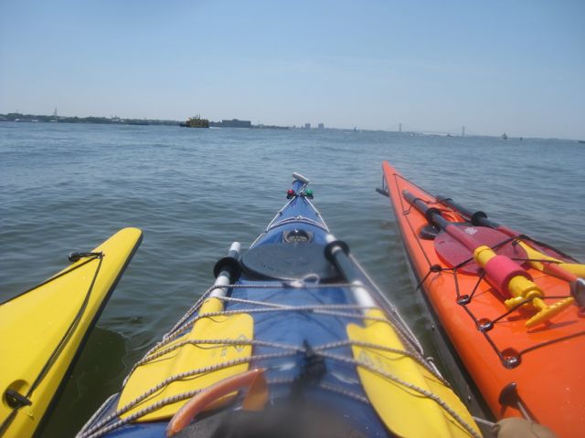
On Saturday, I paddled out to the Narrows with two other women. It was a mostly gorgeous day, and turned out to be a great trip.
The Narrows is the stretch of water between Brooklyn and Staten Island, crossed by the Verranzzano Bridge. It is the boundary between the lower and upper harbors. Past the Narrows, you’re practically at sea, with Long Island out to your left, and Sandy Hook far south on your right.
From where we launch at 56th street, even with a strong favoring current, it’s a three hour trip each way. It also traverses the harbor of one of the world’s busiest cities, so a fair amount of planning was involved. It was a hot day, so we used plenty of protection against the sun (sunscreen, hats, rash guards) and brought along plenty of water.
The trip is best thought of in three stages each way: From Pier 96 (56th street) to Morris Canal; from Morris to Staten Island; along the coast of Staten Island to a long beach known as South Beach just below the Verranzano. Each stage would take about an hour, and we’d follow that route there, with the reverse on the way back.
E and I set out around 11, just short of max ebb. We met up with V at Pier 66 (26th street). With the strong current, it only took us ten or fifteen minutes to get there. V was already on the water, so after greetings and going over the plan, we crossed over to Jersey and made our way towards Morris Canal.
Morris Canal is a relatively wide waterway on the Jersey side of the Hudson. The Colgate Clock – a large mechanical clock on the ground, visible from Manhattan – is near the front. Directly across from the Battery, the canal is between Liberty State Park and some housing developments in New Jersey. It shelters a marina and is a popular destination with our crowd. This is a fairly straightforward paddle, on water we know pretty well.
Below Morris is the NYC harbor. As one might imagine, it has a lot of traffic with no clear lanes. The waters are crisscrossed with water taxis, personal motorboats, sailboats large and small, the Staten Island Ferry, and smaller ferries that transport people to and from Liberty and Ellis islands. Additionally, the underwater topography changes, and when combined with all the traffic, there are a lot of unpredictable currents and wave patterns.
It isn’t as scary as it sounds, but it does require awareness – of other boats and their intentions, of wind and water conditions, and of the potential hazard you might present to others. Conditions can be handled with training – keep a good brace ready and be prepared to power through the waves. Traffic is mostly predictable for the big ships – ferries move along the same paths, and water taxis have known destinations.
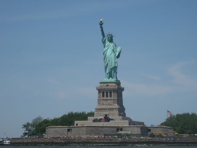
It’s surprising how quickly one arrives at Liberty and Ellis. If you have only been there as a tourist, or seen them from the shore, it’s not clear how close, yet how far they are from the city. They are practically in New Jersey – which means from Morris, they were just a few minutes downstream from us.
I took pictures. I’ve been here once before, on a trip to another destination not quite as far south. It’s nice to have a picture of such a well-known landmark that I took myself, from the water.
As we continued south, we entered a long stretch of water between Liberty and Staten islands. This was the patch I worried about the most, not because of traffic – this area is mostly a parking lot for barges – but because there are no easy places to pull in and take a break. We could stop and drift, or raft up together and take a water break, but there would be no getting out of the boat, or sheltering in from adverse conditions. If the harbor had “next rest stop five miles” signs up, this is where they would be.
Our next major decision was how to cross the flight path of the Staten Island Ferry. The ferry is a large orange ship that crosses between Manhattan and Staten Island on roughly half hour intervals. It does not stop on the water; for our purposes, it cannot stop. There are typically two in motion, one in each direction. Fortunately, unlike water taxis, they tend to move in the same path over and over. Find that path, cross it safely, and they’re not really a problem.
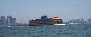
We spotted one ferry on its way out to Staten Island. We had seen its sister pass earlier, so once it was clear, we paddled out into the main channel. From there, we followed channel buoys down to the Narrows, with smoother water and no traffic to speak of. We came across a cargo ship moored in the channel, and wisely went around it before the current could push us into it.
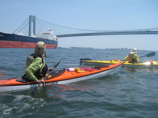
By this point we were in sight of Fort Wadsworth, an old fort on the Staten Island side of the bridge, complementary to Fort Hamilton in Brooklyn.
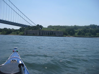
We paddled on, coming up under the bridge and around its western tower. We could see the beach, scraggly at first, but then beyond a short spit, stretching towards a proper boardwalk in the distance.
We popped our skirts – the spray decks that keep us dry, charged in, and jumped out. With that, the first half of our journey was complete. We had arrived at South Beach.
Our next decision was where to land. We wanted bathrooms; “nature” was an option, but real bathrooms couldn’t have been far off. There were some buildings nearby that looked abandoned. The boardwalk looked promising, but was farther down than we wanted, and in any case surf landings are prohibited at swimming beaches during the summer. We spotted some people sitting next to a large inflatable canoe, and aimed for a spot near them.
E and I walked to the boardwalk to freshen up. It was a longer walk there and back than we expected, but a welcome stretching of the legs after sitting in our boats for so long. When we came back, we found V had made acquaintance with our inflatable-boat neighbors. We had lunch, swam a bit in the surf, and rested.
Val got the younger of the two men with the inflatable boat to try out her boat. He was the other man’s son, and in less than an hour she had taught him how to do a wet exit and allowed him to paddle her boat up and down the shore for about thirty yards.
At the Narrows, the tide starts to change sooner than at the Battery; the flood tide was noticeable by three. In fact, while we were swimming, we noticed an acceleration of current carrying us towards the bridge. We weren’t so far out that it was an issue, but we realized it was time to go in and start packing up.
We were back on the water shortly after four. Now, the next phase of our adventure began.
Conditions were different. For one thing, the sky was cloudy, not with storm clouds, but simply high-flying puffy white clouds that screened the sun for a bit of welcome relief. The tide was higher, and rising, changing the nature of some of our landmarks. We noticed that the moored ships we had passed on the way out were now facing south, against the incoming current. Finally, there was also a steady westerly wind.
With the flooding tide and the steady wind, the net effect was that we were generally being carried north and east at the same time. Heading north was fine – that is after all where we wanted to go – but the wind affected how we approached obstacles such as moored ships and barges.
These things are known as strainers. When current runs against a fixed object such as a moored ship or a pier, it can pin a boat or even pull it under. It’s not a pleasant situation to be in, so we wanted to give everyone a wide berth. With the wind as it was, that meant we were paddling out into the channel when we otherwise might have headed back to the west a bit. We had to be a bit more aware of traffic, and had to paddle a bit harder to the west in order to stay on course.
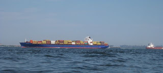
Around this time, cruise ships were starting to depart the city. Altogether we saw three. The first one was approaching the bridge not long after we had left; the last one was rounding the Battery as we were approaching Liberty. The second one was, shall we say, a little more exciting.
We saw this one from a distance. We anticipated its path to be, like the first, well to our right. However, it appeared to be pointed towards our left. As we watched the horizon, we figured it couldn’t keep going in that direction within running into some moored barges that we ourselves were planning to avoid.
Yet, the ship was not turning. We then thought perhaps we were in its path after all, and decided to paddle east, towards Brooklyn. Once we got going, however, then the cruise ship turned.
Cruise ships are big. As big as the Staten Island Ferry is, cruise ships are many times bigger, and like the ferry, they do. not. stop. They can barely turn, constrained as they are by underwater topography and landmarks such as the bridge. So our question was: were we going to pass in front of the ship (unwise) or back-paddle to our earlier spot, hoping that wasn’t the path?
We chose the latter option, and I’m glad we did. I’m not great at gauging distances but I’m reasonably certain we were within 100 yards of the vessel by the time she passed, maybe a long city block away. Now, I’ve been that close to cruise ships before on the water – but from behind, as they’re moving away from me. “That stood my hair on end,” said one of us.
As we paddled across the harbor, the wind would pick up, and then die down again. We realized we were much further east in the channel than we had been coming out. We spotted some channel buoys and headed towards them. We crossed the Staten Island Ferry lines again, and then followed buoys up to more familiar territory.
As the wind picked up intermittently, I found my skeg to be useful in the half-down position. Without it, my boat tended to weathercock, which is to say that I’d get turned by the wind, in this case, in the opposite direction I wanted to travel. With the wind coming at me from the side, having the skeg halfway down kept the wind from turning my boat and allowed me to gradually turn into the wind – a much more favorable position.
E fared a little worse. Her boat is very light, and while it’s short enough to not catch a lot of wind, it takes less wind to weathercock. She dropped her rudder to use as a skeg. That helped a bit, and eventually we passed Liberty, passed some more ferries, and got into the Hudson.
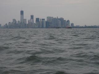
Once there, things were much calmer. For one thing, there was almost no traffic, aside from a motorcycle gang of jet skis that bore down on us like a loud, angry fishing net. The wind died down, leaving us just the current, which carried us like an express train towards our final destinations.
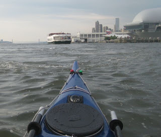
V got out at Pier 66. Adjacent to a popular outdoor restaurant, it was like we dropped her off at a party. We passed a public trip out of Pier 66, a sunset paddle program of the (mostly untrained) public.
E and I continued north, past a couple of ferry terminals, the Intrepid with its now-shrouded space shuttle, and the now-empty cruise ship berths, until we turned in to our embayment at 1906 hours, just a few minutes after our anticipated return time.
Our public program was closed for the day, but some of our friends were there. We talked about the trip, washed our boats, and watched the sun set across the water.
It was an awesome trip. I look forward to many more.
Comments