I had already planned a short paddling trip for Sunday and figured Saturday would be a good day off – catch up on housework, do a little shopping, sleep in perhaps and have a nice warmed muffin from the neighborhood gourmet store. But then, while corresponding with some friends about a get-together we were planning, my friend V mentioned that VS and his brother were planning a trip out to Swinburne Island.
You know, where the seals are.
Swinburne Island, and its larger sibling Hoffman Island, are located off the shore of Staten Island, a mile or two below the Verrazano Bridge – for the more exacting among you, Hoffman’s north edge is about a mile south of the bridge, while the south edge of Swinburne is a two miles below the bridge. Altogether, about twenty miles round-trip, and with the tides as they were, we’d be coming back across the harbor at night. Two firsts for me! I’d only been just past the bridge once, and I’d never been in he harbor proper at night. Well, once, but it was dusk when we started back.
I was a little wary.
First, I wasn’t mentally prepared for a longer trip. Ideations of a cool Saturday morning, the apartment filled with aromas of cinnamon and vanilla, and coffee, dark roasted and French-pressed, dissipated from my mind. Second, Night, plus colder water (temperature just above 50 F), plus multiple major shipping channels = medium consequences.
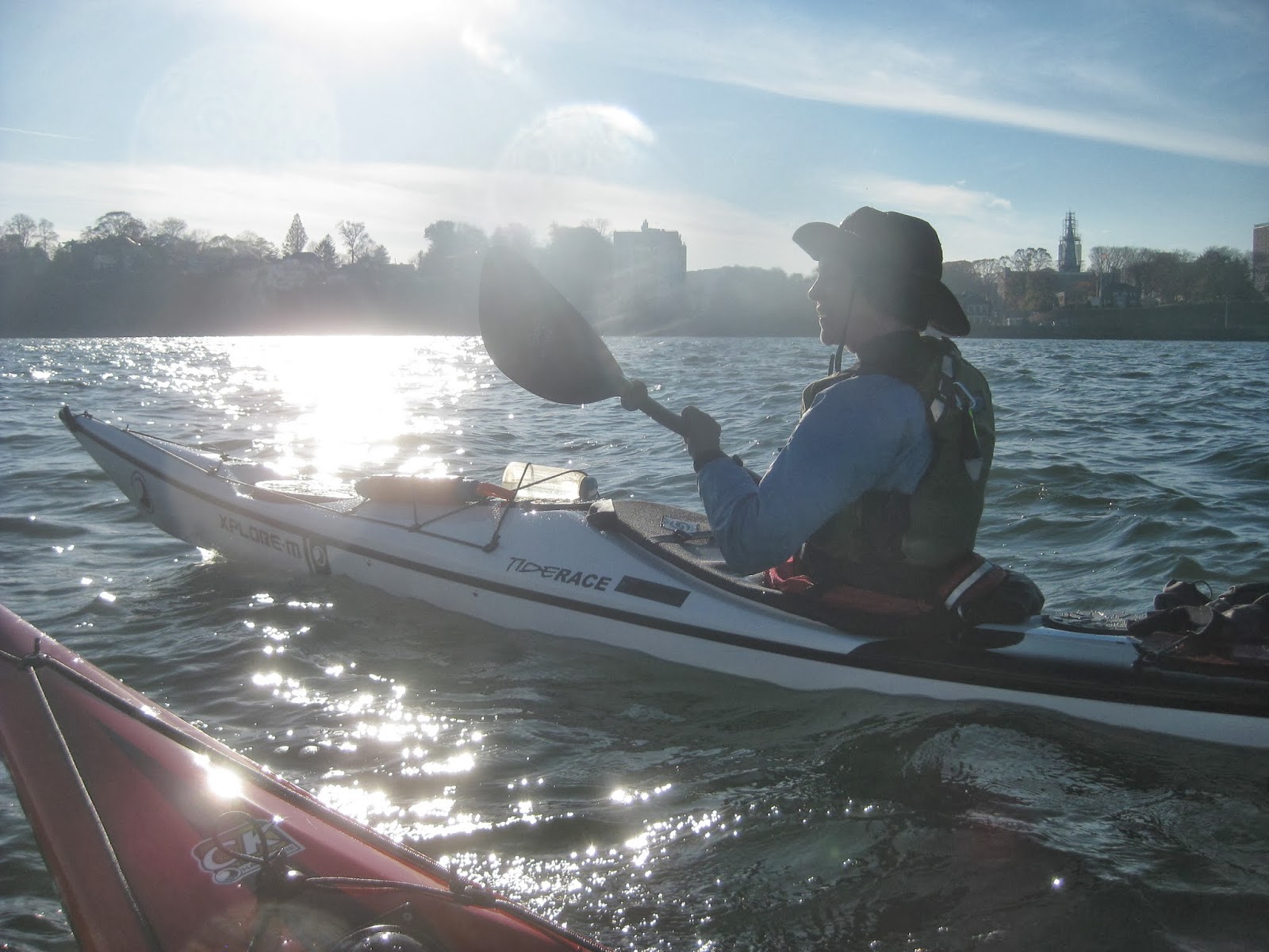
V mentioned it would be the maiden voyage of her new boat, a Tiderace Xplore-M in a white carbon kevlar layup with black trim. “Your boat looks like the space program,” I said when I saw it, recalling film footage from my childhood.
I decided to go.
We launched from Pier 40, and with a strong ebb tide made amazing time. We were past Liberty Island in half an hour, which I work out to at least eight miles an hour. We continued our brisk pace through the harbor, crossing the flight path of the Staten Island Ferry as soon as it was clear, and following a heading directly at the west tower of the Verrazano Bridge.
On the way out, VS kept the radio on. We were surprised at how much chatter was on the official channels. Two guys got in a “You shut up” contest, only with saltier language than this here family-friendly blog allows. Someone else sang the William tell Overture. It was weird.
It was a clear afternoon. We had light headwinds on the way out, but they died down as the day went on. Similarly, the current died down a bit, and after stopping a couple of times for water, and pictures, we were just past the bridge at about two hours trip time – or about four miles an hour.
V and her beautiful new boat.
Some of that time was also spent figuring out traffic. We listened to the radio and watched the Kill Van Kull for outbound traffic. We saw three large container ships moored and weren’t sure if one of them was moving. It wasn’t, but we were moving fast enough, and at an angle, that it looked like it was being brought about by a tug.
We also tried to figure out what was going on with the NYK Laura, an enormous ship that was moored right in the Ambrose Channel, just above the bridge. At a low tide she ought to have been able to move freely under the bridge. A large crane barge was at her port doing something, we weren’t sure what.
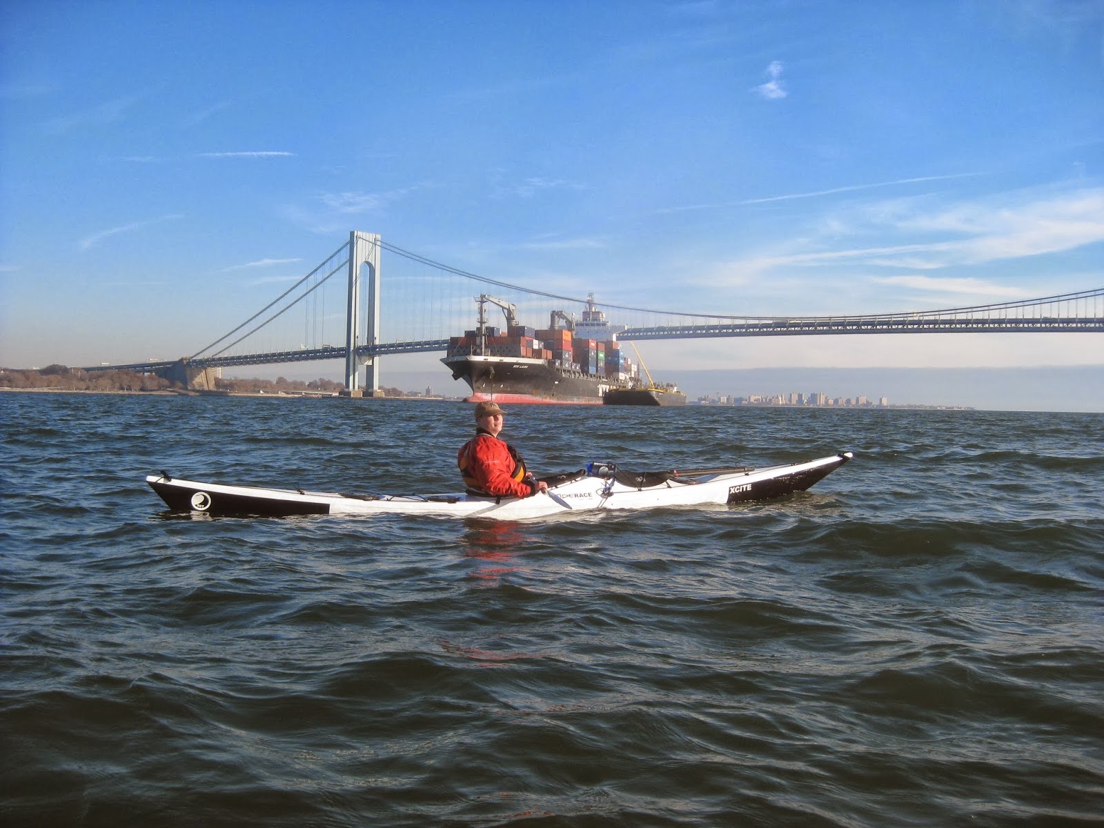
IS posing before the NYK Laura and the Verranzano Bridge.
We saw some other ships, I didn’t get decent pictures of them though, so I’ll cheat and link to fleetmon:
NYK Laura, and all her stats.
The Nord Imagination.
The Singapore Express, which we later saw departing.
By the time the islands were in sight, we were running out of current. We were also slowing down because V had some inflammation in her hand. She broke a finger last spring playing kayak polo, and missed a lot of water time waiting for it to heal. While she can paddle, it’s still tender in different ways – she can tell when a storm’s brewing, and in this case on the way out she’d gotten some swelling. So, she was paddling easy.
Our trip leader gave the go-ahead for IS and I to paddle ahead. I figured it was only a mile, and I could sprint for twenty minutes. I was wrong on both counts.
First, in my enthusiasm I’d only glanced at the chart. We were a mile from Hoffman, but the south end of Swinburne was yet another mile. Second, I can’t sprint for twenty minutes. I’d been paddling enthusiastically already, and got about ten minutes before dropping to my non-tuckered pace. So, altogether, it was another forty minutes or so before we got there.
However, we saw some sights that are unusual on the Hudson. We saw some standing waves, the water baring its teeth, as the tide turned and came in, hitting a change in the seafloor below us. In fact, you can see it on a chart, a little ledge of about ten feet depth next to a channel of twenty-six feet. We caught some nice, gentle swells, lifting our boats up like leaves on a pond, then setting us down, over and over, it might have rocked us to sleep.
As we came around Swinburne, the current had clearly changed, and we were carried rapidly around the south edge of the island, paddling backwards to try and keep position. Enormous swarms of birds flocked over the land and the sea, and we saw the remains of human habitation on the island. Both islands were used for quarantine in the late nineteenth and early twentieth centuries, and later as training bases during World War II. We saw a small cove, and watched, and waited.
Nothing. I was picturing huge mounds of seals, mammals falling all over each other, sunning themselves on such a gorgeous day, seals like I’ve seen in California, in Monterey and San Francisco. Instead, I saw rocks, rocks and birds.
Then, something moving, a long, but a limber log, slipping into the water in a way that the currents couldn’t.
“I see one!” IS pointed in front, which was to my left. I watching my own, and saw the log dive underwater.
I scanned the horizon, along with V. We saw something else, bobbing, yes! A little jump up in the water, and then he disappeared beneath the waves.
I’m certain we saw them. I was hoping for photos, but got none. We were running out of daylight, and current besides, and so we headed back, to our dinner stop, Alice Austen House, just a mile or so northwest of the bridge, stopping only to watch the Singapore Express slip under the bridge on her way out to sea.
On the way back, we overheard a distress call, answered by the Coast Guard, but not in visual range. A vessel had a three foot hole and was taking on water. Bad things do happen at sea, even on a peaceful day.
I can’t recall ever having a sugar crash. I wasn’t even thinking I was having one until later. As we paddled back, I was tired, but not exhausted. I straightened up my form, kept my paddling discipline, but I felt faded. I wasn’t sleepy, I wasn’t physically exhausted, I was just focused. The thousand-yard stare. Where’s my next waypoint? I could keep going.
VS asked me to come closer to the group. I was trying to catch current. He later said I looked pale, and that worried me. We made it back OK, and for the first time I could recall, the thing I craved most was sugar over carbs or even protein. After a sip of tea I tore into an oatmeal cookie and immediately felt ten times better.
We moved our boats up above the incoming tide line, and relocated lunch to a bench overlooking the harbor. The one miscalculation made in the trip was that the House, a historic museum, was closed, so no running water for washing hands or bathrooms. We did find a chemical toilet though.
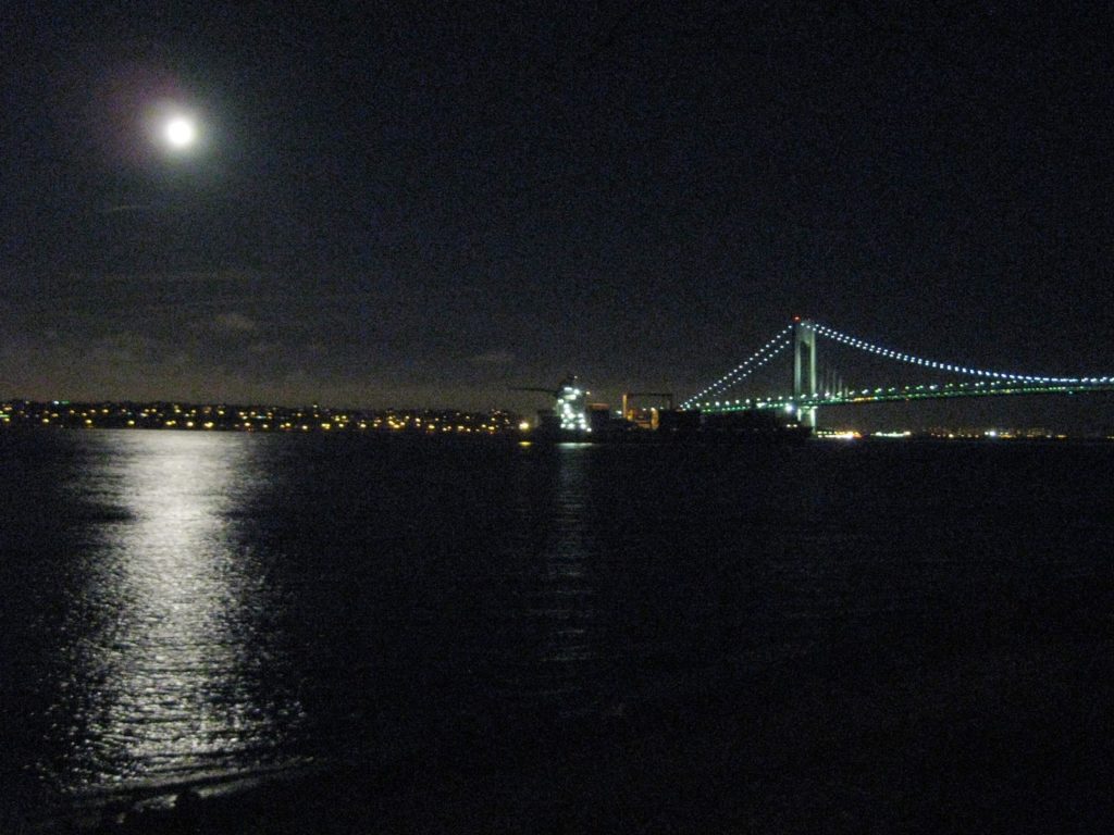
On the way back, I’d seen the moon, low over the horizon in the late afternoon, climb steadily, until now, in the night, it was high in the sky, a Full Moon, bright and white, with clear skies, illuminating the harbor. My camera doesn’t do it justice, but this was the scene:
I took group photos, first of VS, V, and IS.
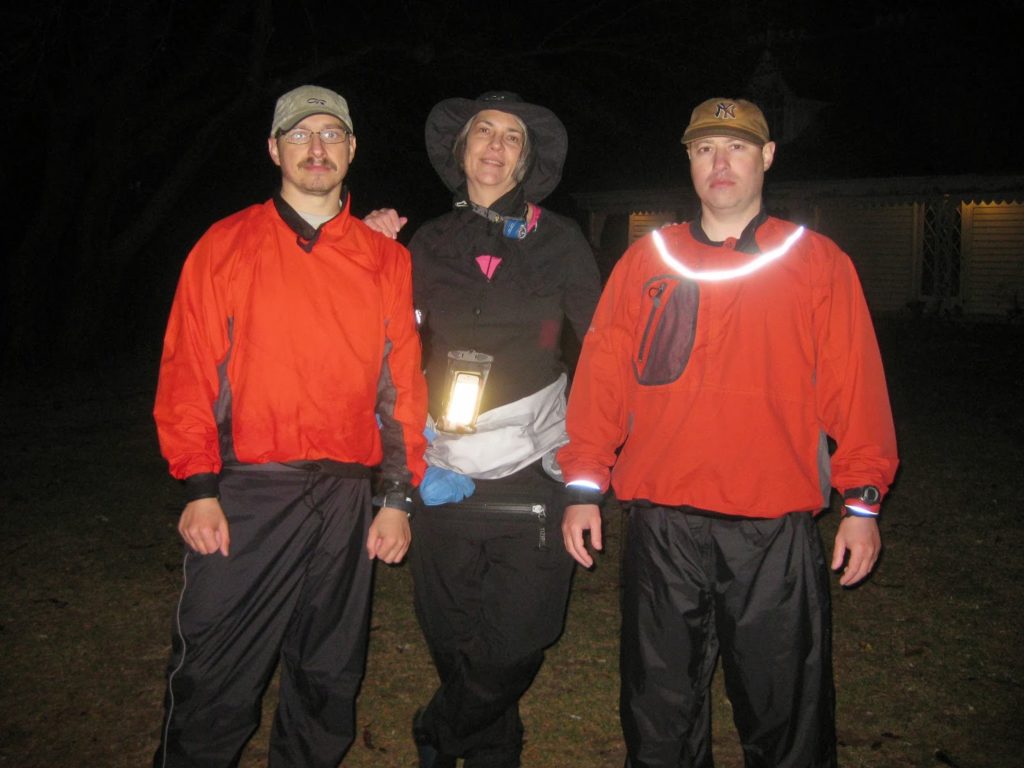
Then, me, V, and IS.
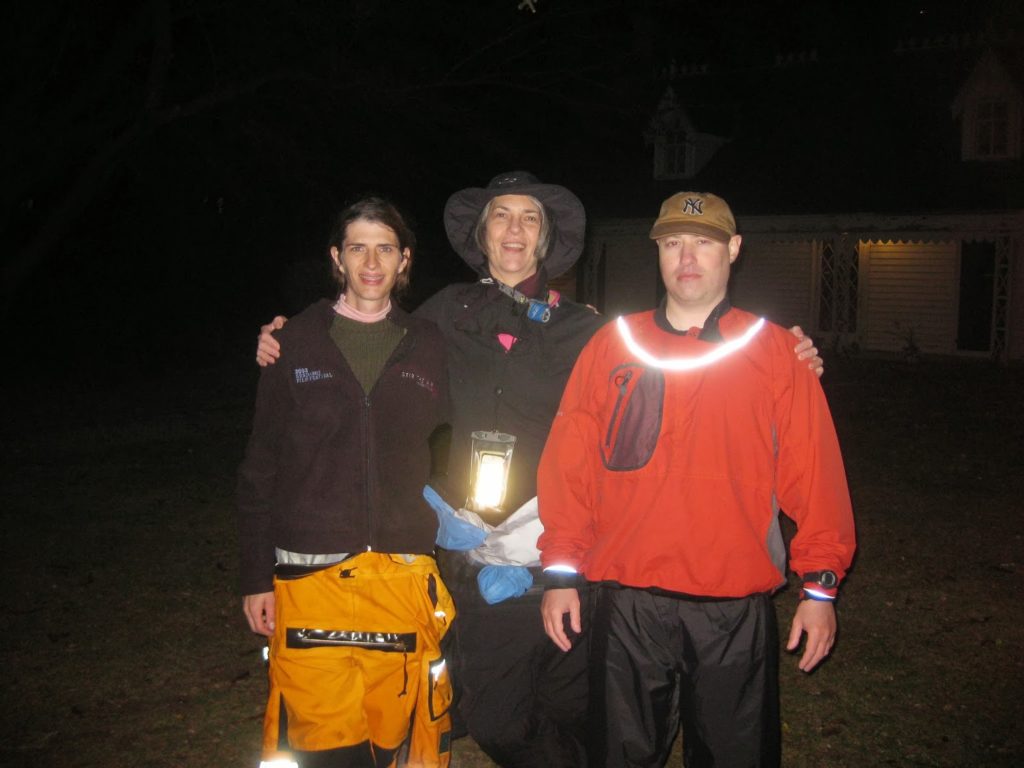
What is it with Russians? They never smile!
After resting and eating and admiring the view, we packed up and prepared to head back. VS suggested crossing the harbor to head up on eastern side of it, where the currents were stronger. Again, I was dubious – crossing the harbor at night? I could already see a fast-moving tug and its barge. While citing speed as an issue, I think VS also didn’t want to pass in from of the Kill Van Kull, which alone has a lot of traffic, and also, putting off the Staten Island Ferry until Battery. I agreed, and off we went, crossing the upper harbor by the light of the moon, as the flood tide ferried us north a bit.
Once over, we turned north, and made out some parked barges and Governors Island. It’s hard to judge distance at night. Two lumpy objects next to each other might be hundreds of yards apart. We ended up aiming towards a large barge with stadium lights, orienting between that and the Freedom Tower and Governors Island. Once the Staten Island Ferry passed, we headed towards some blue lights hanging above South Cove, and thence onwards to Pier 40.
On the way back, we overheard some interesting radio chatter, the most notable was a restaurant vessel behind a harbor cruise vessel asking if she was going to maintain her speed, because the first vessel was overtaking her. The tone was exactly New York, “could you hurry it up please.”
Back home, we carried up, washed up, and packed up, before heading out, another great trip done, nearly on a lark.
Comments